

The emergence of sub-centres in the wider Budapest metropolitan region is driven primarily by motorway access, rather than rail connections, according to new research published in the Journal of Urban Affairs.
The study, conducted by János B. Kocsis and Virág Varga of Corvinus University of Budapest, analysed 203 settlements in the capital’s agglomeration, assessing their economic, labour market and service-related roles within the wider urban system.
According to the authors, Budapest’s distinctive development pattern means that the concept of traditional, city-internal sub-centres can only be applied to a limited extent. Instead, the most meaningful central functions emerge outside the city core, within the surrounding agglomeration.

The results show that primary centres are concentrated mainly in the northern, northeastern and western parts of the metropolitan area. By contrast, the northwestern, southern and southeastern zones contain fewer settlements with strong, diversified service portfolios and labour market functions.
In the north-west, development is constrained by geographical barriers, weak accessibility and missing cross-connections. Meanwhile, the southern belt does feature several emerging hubs, but these tend to be less developed, focusing largely on logistics and industrial activity rather than higher-level urban functions.
Budapest southwest emerges as the strongest zone
The most powerful cluster is found in the southwest, with Budaörs, Törökbálint and Diósd forming a highly integrated trio. In the north, Budakalász and Szentendre stand out, alongside Dunakeszi and Vác, while Gödöllő represents the main centre in the northeast.
These towns clearly distinguish themselves from their surroundings through stable economic performance, higher-level services, and functions that serve broader catchment areas beyond their immediate populations.
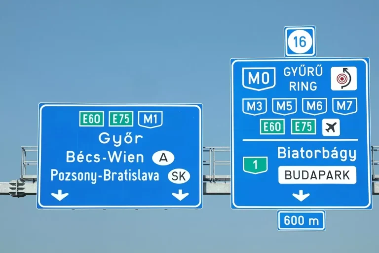
In addition, six secondary centres were identified: Biatorbágy, Dunaharaszti, Érd, Monor, Szigetszentmiklós and Vecsés. Notably, the absence of major sub-centres in the northwestern zone is closely linked to accessibility issues, as this section of the M0 ring road remains incomplete.

Potential centres and functional gaps
Beyond the main and secondary hubs, the study highlights 14 local centres with strong economic and labour market roles, including Dabas and Százhalombatta, which could gradually evolve into residential and recreational centres as well.
Another nine settlements, such as Pomáz and Ercsi, were classified as potential lower-level centres. These locations already have solid local labour markets and retail activity, and targeted improvements in transport and basic services could enable upward movement in the hierarchy.
At the same time, the researchers identified functional gaps in 149 settlements, while nine settlements function almost exclusively as residential areas. A further eight holiday settlements, including Taksony and Kisoroszi, possess strong cultural, hospitality and sports offerings, but lack several basic central functions needed to strengthen their regional roles.
Motorways matter most
The study’s key conclusion is clear: proximity to motorways is the single most important factor behind the emergence and strengthening of sub-centres in the Budapest agglomeration.
Rail connectivity, by contrast, plays a secondary role, with only a weak but measurable correlation, primarily linked to residential functions. The findings suggest that future regional development patterns will continue to follow road infrastructure.


